

Chenango Canal Survey, Sherburne showing Skinner and Puddleford
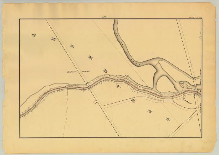
This is an ink, wash and charcoal map of a section of the Chenango Canal Feeder in Sherburne. It shows Feeder No. 1 running along the Chenango River which branches off into multiple streams. Also shown are five bridges, three buildings and four unidentified roads. Two of these roads cross the canal. The red lines indicate courses and distances. The blue lines indicate canal right-of-way. The map also shows the properties of Benjamin Skinner and H. Puddleford.
Identifier
NYSA_A0848-77_MC8_DR1_V17_CHEN2_183
NYSA_A0848-77_MC8_DR1_V17_CHEN2_183
Date Original
1838
1838
Language
English
English
Source
New York State Archives, A0848-77, Canal System Survey Maps, 1832-1843, Map no. CHEN2-183
New York State Archives, A0848-77, Canal System Survey Maps, 1832-1843, Map no. CHEN2-183
Rights
This image is provided for education and research purposes. Rights may be reserved. Responsibility for securing permissions to distribute, publish, reproduce or other use rest with the user. For additional information see our Copyright and Use Statement
This image is provided for education and research purposes. Rights may be reserved. Responsibility for securing permissions to distribute, publish, reproduce or other use rest with the user. For additional information see our Copyright and Use Statement
More From This Series
Canal Commissioners canal system survey mapsGeographic Locations
Chenango CountyThe New York State Archives is part of the Office of Cultural Education, an office of the New York State Education Department.
To report technical problems with this web site, please contact the New York State Archives at archinfo@nysed.gov