

Chenango Canal Survey, Eaton showing West Branch Feeder, and the Eaton, Lebanon and Hamilton Town Lines
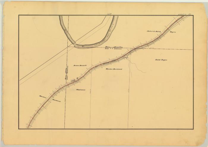
This is an ink, wash and charcoal map of a section of the Chenango Canal Feeder in Eaton. It shows the West Branch Feeder, the West Branch of the Chenango River, the Hamilton and Lebanon Town Line, the Eaton and Lebanon Town Line, a small square shaped basin, two bridges, two buildings and an unidentified road. The red lines indicate courses and distances. The blue lines indicate canal right-of-way. The map also shows the properties of Theodore Burchard, James Russell, Medad Rogers, Josiah Rogers and Woodman.
Identifier
NYSA_A0848-77_MC8_DR1_V17_CHEN2_167
NYSA_A0848-77_MC8_DR1_V17_CHEN2_167
Date Original
1838
1838
Language
English
English
Source
New York State Archives, A0848-77, Canal System Survey Maps, 1832-1843, Map no. CHEN2-167
New York State Archives, A0848-77, Canal System Survey Maps, 1832-1843, Map no. CHEN2-167
Rights
This image is provided for education and research purposes. Rights may be reserved. Responsibility for securing permissions to distribute, publish, reproduce or other use rest with the user. For additional information see our Copyright and Use Statement
This image is provided for education and research purposes. Rights may be reserved. Responsibility for securing permissions to distribute, publish, reproduce or other use rest with the user. For additional information see our Copyright and Use Statement
More From This Series
Canal Commissioners canal system survey mapsGeographic Locations
Madison CountyThe New York State Archives is part of the Office of Cultural Education, an office of the New York State Education Department.
To report technical problems with this web site, please contact the New York State Archives at archinfo@nysed.gov