

Erie Canal Survey, Little Falls showing Village of Little Falls
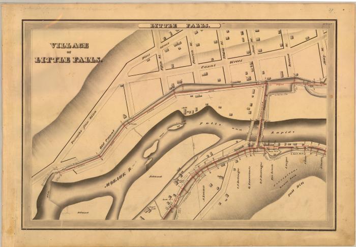
This is an ink, wash and charcoal map of a section of the Erie Canal in Little Falls. It shows the Village of Little Falls, the Mohawk River, a series of dams and islands, an old canal, the Falls and rapids, an aqueduct and canal feeder, Fall Hill, Lock No. 8, 9 and 10, eight bridges, over a hundred buildings including two paper mills, 1st Street, 2nd Street, 3rd Street, 4th Street, 5th Street, Ann Street, Canal Street and the Turnpike to Utica. The red lines indicate courses and distances. The blue lines indicate canal right-of-way. The map also shows the properties of C.P. Bellinger, G. Rosecrantz, Ten Broeck, J. Dygert, E. Ellis and N. Casler.
Identifier
NYSA_A0848-77_MC7_DR8_V8_E8_37
NYSA_A0848-77_MC7_DR8_V8_E8_37
Date Original
1834
1834
Language
English
English
Source
New York State Archives, A0848-77, Canal System Survey Maps, 1832-1843, Map no. E8-37
New York State Archives, A0848-77, Canal System Survey Maps, 1832-1843, Map no. E8-37
Rights
This image is provided for education and research purposes. Rights may be reserved. Responsibility for securing permissions to distribute, publish, reproduce or other use rest with the user. For additional information see our Copyright and Use Statement
This image is provided for education and research purposes. Rights may be reserved. Responsibility for securing permissions to distribute, publish, reproduce or other use rest with the user. For additional information see our Copyright and Use Statement
More From This Series
Canal Commissioners canal system survey mapsThe New York State Archives is part of the Office of Cultural Education, an office of the New York State Education Department.
To report technical problems with this web site, please contact the New York State Archives at archinfo@nysed.gov