

Erie Canal Survey, Mentz showing Montezuma and Canal Junction
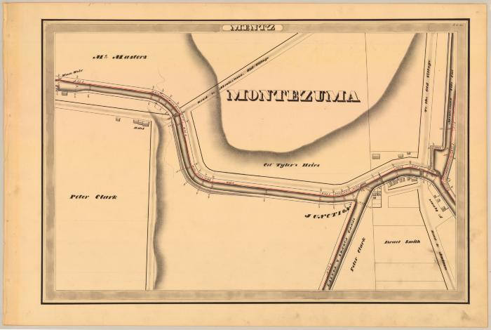
This is an ink, wash and charcoal map of a section of the Erie Canal in Mentz. It shows the Town of Montezuma, a waste weir, a waterway called the Montezuma Side Cut which empties into a large basin and into the canal, the junction of the Erie Canal and the Cayuga and Seneca Canals, four bridges and eighteen buildings. Also shown are Public Square, the Road to Montezuma and the Road to Auburn. The red lines indicate courses and distances. The blue lines indicate canal right-of-way. The map also shows the properties of McMasters, Peter Clark, Col. Tyler’s Heirs and Israel Smith.
Identifier
NYSA_A0848-77_MC7_DR5_V5_E5_21
NYSA_A0848-77_MC7_DR5_V5_E5_21
Date Original
1834
1834
Language
English
English
Source
New York State Archives, A0848-77, Canal System Survey Maps, 1832-1843, Map no. E5-20
New York State Archives, A0848-77, Canal System Survey Maps, 1832-1843, Map no. E5-20
Rights
This image is provided for education and research purposes. Rights may be reserved. Responsibility for securing permissions to distribute, publish, reproduce or other use rest with the user. For additional information see our Copyright and Use Statement
This image is provided for education and research purposes. Rights may be reserved. Responsibility for securing permissions to distribute, publish, reproduce or other use rest with the user. For additional information see our Copyright and Use Statement
More From This Series
Canal Commissioners canal system survey mapsThe New York State Archives is part of the Office of Cultural Education, an office of the New York State Education Department.
To report technical problems with this web site, please contact the New York State Archives at archinfo@nysed.gov