

Erie Canal Survey, Lyons showing Public Square and Clyde River
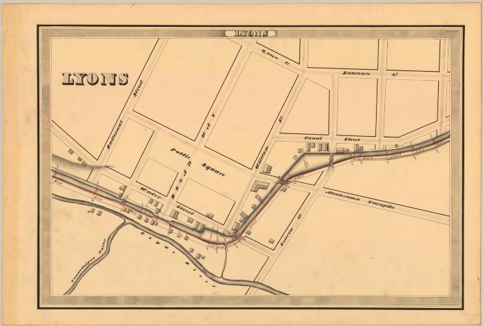
This is an ink, wash and charcoal map of a section of the Erie Canal in Lyons. It shows the Town of Lyons, the Clyde River, Canandaigua Outlet which connects to the river, a small channel that runs from the river to the canal, a large triangle shaped basin, four bridges, and forty-nine buildings. The red lines indicate courses and distances. The blue lines indicate canal right-of-way. The map also shows Butternut Street, Broadway, Water Street, Queen Street, William Street, Canal Street, Laurence Street, Geneva Street, Montezuma Turnpike and Public Square.
Identifier
NYSA_A0848-77_MC7_DR4_V4_E4_48
NYSA_A0848-77_MC7_DR4_V4_E4_48
Date Original
1834
1834
Language
English
English
Source
New York State Archives, A0848-77, Canal System Survey Maps, 1832-1843, Map no. E4-48
New York State Archives, A0848-77, Canal System Survey Maps, 1832-1843, Map no. E4-48
Rights
This image is provided for education and research purposes. Rights may be reserved. Responsibility for securing permissions to distribute, publish, reproduce or other use rest with the user. For additional information see our Copyright and Use Statement
This image is provided for education and research purposes. Rights may be reserved. Responsibility for securing permissions to distribute, publish, reproduce or other use rest with the user. For additional information see our Copyright and Use Statement
More From This Series
Canal Commissioners canal system survey mapsThe New York State Archives is part of the Office of Cultural Education, an office of the New York State Education Department.
To report technical problems with this web site, please contact the New York State Archives at archinfo@nysed.gov