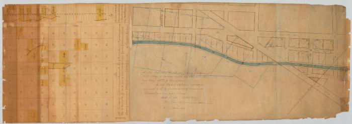
Map of the Salt Manufacturing Lots laid out in the Village of Syracuse and Lots in the Town of Pharsalia. Map #311A-311B
Map representing the Salt Manufacturing Lots laid out in the Village of Syracuse and Lots and blocks in the rear thereof reduced by their extension; as also the lots and blocks in said Village appraised to the occupants and owners of improvements, pursuant to a law passed in 1829. February 20th, 1830. Ashbel Kellogg.
Map of lots, and parts of lots of Land, belonging to the People of the State of New York, in the Town of Pharsalia, County of Chenango. Surveyed by direction of Simeon DeWitt, Esq., Surveyor General. August, 1826. By Peleg Gifford, Deputy Surveyor.
Map of lots, and parts of lots of Land, belonging to the People of the State of New York, in the Town of Pharsalia, County of Chenango. Surveyed by direction of Simeon DeWitt, Esq., Surveyor General. August, 1826. By Peleg Gifford, Deputy Surveyor.
Identifier
NYSA_A0273-78_311A-311B
NYSA_A0273-78_311A-311B
Date Original
1826 – 1830
1826 – 1830
Contributor
Kellogg, Ashbel; Gifford, Peleg (surveyor)
Kellogg, Ashbel; Gifford, Peleg (surveyor)
Language
English
English
Source
New York State Archives. New York (State). State Engineer and Surveyor. Survey maps of lands in New York State, ca. 1711-1913. Series A0273-78, Map #311A-311B.
New York State Archives. New York (State). State Engineer and Surveyor. Survey maps of lands in New York State, ca. 1711-1913. Series A0273-78, Map #311A-311B.
Rights
This image is provided for education and research purposes. Rights may be reserved. Responsibility for securing permissions to distribute, publish, reproduce or other use rest with the user. For additional information see our Copyright and Use Statement
This image is provided for education and research purposes. Rights may be reserved. Responsibility for securing permissions to distribute, publish, reproduce or other use rest with the user. For additional information see our Copyright and Use Statement


