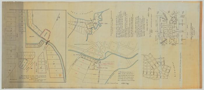
Map of the Villages of Geddes, Geddesburgh, Liverpool and 15 Acre Marsh lot No. 42. Map #303 (Copy)
Map of Basin Lots in the Village of Geddes. Surveyed Oct. 1829. And part of the Village Lots in the Town of Salina, Onondaga County. By Calvin Guiteau.
Map of survey and description of 15 Acre Marsh Lot No. 42 in possession of Fisher Curtis. Dated Aug. 10, 1830. Ashbel Kellogg.
Map of part of Geddesburgh in 1822, by John Randel, Jun.
Map showing part of the Village of Geddes, as also 7 water lots laid out along the eastern side of the Erie Canal between the Seneca Turnpike and the road leading from Salina to Geddes. Also two subdivisions of farm lot 324. Dated Jan. 10, 1831. By Ashbel Kellogg.
Map of the Village of Liverpool.
Identifier
NYSA_A0273-78_303_copy
NYSA_A0273-78_303_copy
Date Original
1822 – 1831
1822 – 1831
Language
English
English
Source
New York State Archives. New York (State). State Engineer and Surveyor. Survey maps of lands in New York State, ca. 1711-1913. Series A0273-78, Map #303 (copy).
New York State Archives. New York (State). State Engineer and Surveyor. Survey maps of lands in New York State, ca. 1711-1913. Series A0273-78, Map #303 (copy).
Rights
This image is provided for education and research purposes. Rights may be reserved. Responsibility for securing permissions to distribute, publish, reproduce or other use rest with the user. For additional information see our Copyright and Use Statement
This image is provided for education and research purposes. Rights may be reserved. Responsibility for securing permissions to distribute, publish, reproduce or other use rest with the user. For additional information see our Copyright and Use Statement


