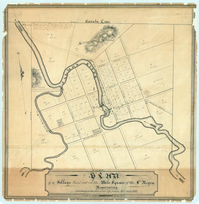
Map of a village laid out in the mile square in the St. Regis Reservation, 1820
Hand drawn map of a village laid out in the mile square in the St. Regis Reservation pursuant to Chapter 194, passed April 1818. Done according to law, 1820, Simeon DeWitt, Surveyor General. Scale of 4 chains to an inch. Map of land divided into numbered lots showing acreage, laid out on named streets, with survey notes about certain lots and surrounding land. Salmon and Little Salmon Rivers run through the village. See similar map no. 156. Original map size 29” x 28”.
Map of a Village laid out in the Mile Square of the St. Regis Reservation, pursuant to the act, Chap. 194, passed 20th April, 1818. R. V. De Witt, 1819. [Franklin County]
Map of a Village laid out in the Mile Square of the St. Regis Reservation, pursuant to the act, Chap. 194, passed 20th April, 1818. R. V. De Witt, 1819. [Franklin County]
Identifier
NYSA_A0273-78_196
NYSA_A0273-78_196
Date Original
1820
1820
Language
English
English
Source
New York State Archives, Series A0273-78, Survey maps of lands in New York State, [ca. 1711-1913] (bulk ca. 1772-1913). Map 196.
New York State Archives, Series A0273-78, Survey maps of lands in New York State, [ca. 1711-1913] (bulk ca. 1772-1913). Map 196.
Rights
This image is provided for education and research purposes. Rights may be reserved. Responsibility for securing permissions to distribute, publish, reproduce or other use rest with the user. For additional information see our Copyright and Use Statement
This image is provided for education and research purposes. Rights may be reserved. Responsibility for securing permissions to distribute, publish, reproduce or other use rest with the user. For additional information see our Copyright and Use Statement


