

Industrial Park Area, N.Y.
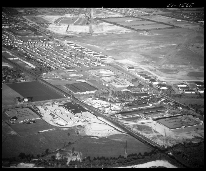
Aerial view of an industrial park area looking to the southeast, with a view of the recently closed Roosevelt Field Airport. The hanger line is visible along Old Country Road, which runs parallel to the railroad tracks. At the top left is Roosevelt Raceway, and at the top right is the Meadowbrook Club polo fields. Roosevelt Field Airport was purchased by real estate developers and officially closed on May 31, 1951. Demolition started only months after this photo was taken to make way for Roosevelt Field Shopping Mall and light industry. By 1956 the Meadowbrook State Parkway would divide this area from upper right to center left. The tree-lined pathway at the very bottom in the abandoned Vanderbilt Parkway was used as a power line tower right-of-way. The light colored building in the lower left of center (adjacent to the railroad tracks) is the soon to be completed Consolidated Lithographing building referenced in NYSA_B1598-99_4588.
Identifier
NYSA_B1598-99_B1F83_51-1565
NYSA_B1598-99_B1F83_51-1565
Date Original
June 6 1951
June 6 1951
Language
English
English
Source
New York State Archives, Aerial photographic prints and negatives of New York State sites, 1941-1957, B1598-99 Box 1, Folder 83, Negative Number 51-1565
New York State Archives, Aerial photographic prints and negatives of New York State sites, 1941-1957, B1598-99 Box 1, Folder 83, Negative Number 51-1565
Rights
This image is provided for education and research purposes. Rights may be reserved. Responsibility for securing permissions to distribute, publish, reproduce or other use rest with the user. For additional information see our Copyright and Use Statement
This image is provided for education and research purposes. Rights may be reserved. Responsibility for securing permissions to distribute, publish, reproduce or other use rest with the user. For additional information see our Copyright and Use Statement
More From This Series
Aerial photographic prints and negatives of New York State sitesThe New York State Archives is part of the Office of Cultural Education, an office of the New York State Education Department.
To report technical problems with this web site, please contact the New York State Archives at archinfo@nysed.gov